
Facts and Statistics
 The Colorado Trail extends for 485 miles, starting in the foothills in the southwest of Denver, passing through the most mountainous regions in the state. Its conclusion is around 5.6 km north of Durango. The elevations on the trail range from a high of 4,045 on the slopes of Coney, to a low of about 1,700 m at the Denver section of the trail. The trail falls and rises dramatically. If you hike the entire trail, you are likely to gain and lose around 89,000 feet.
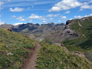
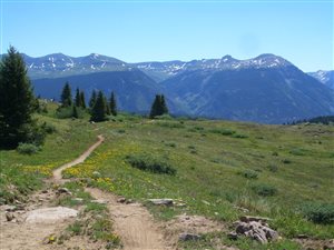
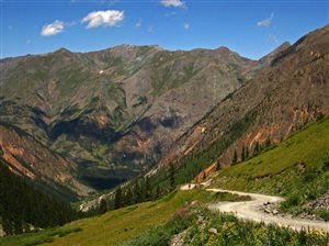
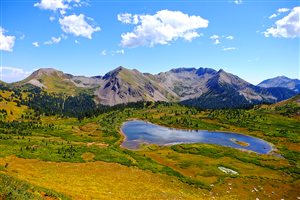
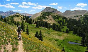
During its course, it passes through eight mountain ranges, five river systems, six wilderness areas, and six national forests, making it a truly natural wonderland. It passes some of the most beautiful lands, among wildflowers and wildlife abounds. Although a large section of the trail passes through forests, a good section is well above the tree line. Views are breathtaking all over the trail.
The trail traverses ancient Indian trails, historic mining towns, and through a world class and modern ski resort. Most sections of the trail remain, as they would have appeared 500 years ago. The western sections of the trail, especially between Monarch Pass and Durango have experienced less human influence. Spectacular wildflowers and greater vistas are on display. For more than 378 km, this trail coincides with the Continental Divide Trail (CDT) on the Collegiate East route. Along the Collegiate West route, this hiking trail follows the CDT for more than 80 miles.
Best Time for Hiking
 The hiking window for this trail is somehow narrow. The hiking window spans from mid-late June to and not later than early October. Hiking before mid late June is problematic, since there is too much snow. After early October, you are likely to encounter regular snowstorms. As such the snow is likely to accumulate and the melting will be too slow even during the day.
Considering the large number of outsiders who will be hiking this trail, a safe date to plan would be from 1st July. If you are headed to Denver, you can extend your hiking season by around one week, since you will be now hiking the lower elevations. However, this time frame is not fixed, since it can change depending on the hiking pace, snow pack, and rate of snow melt.
General Safety
 The trail is properly marked making navigation very easy. The weather hazards are easy to deal with a properly executed advance planning. In terms of logistics, the trail is easy to manage. It is a great trail even for first timers. If you plan to hike alone, you can do it between the July and August. However, it is still easy to hike with others. You are likely to encounter others along the way. If you still insist on hiking solo, arrange your hike towards fall.
You will need to hitch to town, in order to resupply. Locals are used to the numerous hikers that visit the Colorado Trail every year; therefore, getting a lift will not be a problem. If you feel uncomfortable hitch hiking alone, then you can arrange with a fellow hiking partner. You can also get a ride at the trailhead, as many people are leaving for town.
 In terms of network coverage, there is excellent network coverage beyond Denver and around Copper Mountain. After Copper Mountain, network coverage can be shaky, depending on the travel direction. If you are hiking around busy roads, then the network coverage is stable. However, do not depend on your cellular network for safety.
Most hikers are very concerned about lightning and thunderstorms in the area. During summer, thunderstorms start forming just past midday, until the early evening. When planning the ground you want to cover for the day, always have that in mind. It is always consistent, therefore, don’t take chances.
Some hikers have observed black bears on this trail. However, they are not aggressive, as compared to those found at the High Sierra. You will most likely find them at the valleys. They are not common.
Thru-hiking
 Most thru hikers prefer to do it from east to west. The reason why this direction is preferred is that snow tends to melt earlier during the year on the eastern segment that on the western segment. Additionally, if you hike from east to west, you will be able to gain elevation gradually, building up to the sections of the trail that are more rugged, especially in the San Juan Mountains. In these sections, you are going to need quality hiking boots.
The time varies for completing the entire trip. Some trail runners can do it within a period less than ten years. However, most thru-hikers spend around five to six weeks. Again, your time will depend on the weather conditions, your hiking speed and trail conditions.
Resupply
 Resupply is not hard, but choices are minimal. Due to the short length of this hiking trail, you can opt for mail drops, as a viable option. It is a good choice for thru hikers who are on a limited time, and fast pace. Hiking the Colorado Trail is not a right, but a privilege; therefore, it is good to observe courtesy.
Do not feel like you are entitled to any service; respect the people in towns and your fellow hikers. Some of the popular resupply points include Denver, Buffalo Creek, Bailey, Jefferson, Frisco, Leadville, and Twin Lakes. Others include Buena Vista, Salida, Sargents, Gunison, Creede, Lake City, Silverton, Molas Lake Campground among others.
Alternative Routes
One factor that makes the Colorado Trail a big attraction is the presence of alternative routes. Some hikers choose to travel along this trail for some time and then veer off to the harder trails, that are more scenic. Check your maps and identify the alternative trails and what can work best for you. Some of the alternative routes that you can follow include the Lost Creek Wilderness High Route, Hope Pass, Missouri Gulch, and the Collegiate West.
Because of its sheer ruggedness, altitude, length, and other factors, hiking the Colorado Trail can be somehow challenging, especially for a beginner. Hiking the entire trail can take you up to eight weeks. However, you can do it in smaller portions.
Conclusion
Thru-hikers and backpackers have described this trail as life changing and an amazing experience. It is good to be familiar with basic hiking and navigation techniques, to ensure a smooth and comfortable hike.
YouTube User ‘Matthew Foote’ Thru Hikes The Colorado Trail
Navigation
[jbio template=”bootbomb0″]
0 comments