
Facts and Statistics
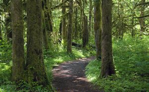
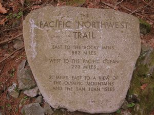 The Pacific Northwest Trail is a unique pathway travelling through some of the most scenic and spectacular terrains in the US. It connects communities and people living in the Pacific Northwest. It is ranked among the most scenic trails all over the world. The trail starts in the Glacier National Park, near the Continental Divide, travelling through Montana, Idaho, and Washington for more than 1200 miles. It then reaches its western terminus near Cape Alava, at the Pacific Ocean.
This trail travels through remote, rugged wilderness and main streets in some small communities. In some areas, it is characterized by hundreds of people, while others are only navigated by a handful of hikers. Some people will only travel a few miles. However, if you want to experience the full scenic feel, then plan to cover the entire trail.
History
 This trail was first discovered and explored around the 1970s by Ron Strickland. The Pacific Northwest Trail Association was founded by Ron in 1977 to maintain the route. The organization also educates the public about this trail. This trail was designated as a national scenic trail back in the year 2009. It is administered by the Department of Agriculture.
Route Description
The official start of this trail is the Chief Mountain Customs found on the US-Canadian border in Glacier National Park. The trail passes through the valleys and high mountains of Glacier National Park, travelling through the Flathead River, across the Whitefish divide, traversing through Ten Lakes Scenic Area. The trail then cuts across Lake Koocanusa, before finding its way through the Yaak River, descending to the Moyie River to the Northeast side of Idaho.
 From the Moyie River, this trail passes through dikes, farmlands, and forestlands of the Kootenai River Valley. It then ascends all the way to the Selkirk Crest, before descending into the Priest Lake State Forest, via Lions Head. The trail follows a path up to the Upper Priest Lake via the Salmo-Priest wilderness. It then passes through the Boundary Dam, continuing over Abercombie Mountain. The Pacific Northwest trail then passes through the small town of Northport all the way to the Colombia River.
The Idaho wilderness experiences minimal traffic, apart from the handful of hunters who visit the area. However, you can still identify few camping spots for backpackers. Areas such as Ball Lakes have been known to attract huge crowds of hikers during the summer heat.
 After that section, the trail traverses the Kettle Crest through the forested and mining areas of North Central Washington. Another section of this trail passes through the orchards and rangelands of Okanogan River Valley. The Okanogan highlands form the largest geographic area in the entire section of this trail. It includes rugged mountain ranges mixed with river valleys and rolling hills.
The trail then begins ascending Pasayten wilderness. These are some of the most remote areas in the Lower 48 areas of the US. The Pasayten wilderness is in the northern cascades of this trail. Large parts of this section are very challenging to access, considering they pass through a wilderness that is rarely explored. The Pasayten section is around 25 miles characterized by a roadless wilderness. You will come across the Boundary trail number 533 that provides spectactular walking at over elevations of more than 7,000 feet. Beware though, you’ve gotta be wearing quality walking shoes to get the most out of it. Sections of lush river valleys and dips make it even more exciting.
The trail then cuts through the Mt Baker Wilderness, then state, private and federal woodlands before reaching Puget Sound. Through the farmlands and along the dikes Skagit County, the PNT crosses Fidalgo Island. This is the section at Deception Pass State Park. It will then lead you to the Washington state ferry. This is the only ferry crossing in the entire National Trails System. This makes the trail unique and different from the other trails.
 You will then take a thirty-minute ferry ride across the channel. The trail continues on the other side of the seaside community of Port Townsend. It splits into three trails at this section. These are The PNT, the Larry Scott Trail, and the Olympic Discovery Trail. Each trail then goes its separate direction. At this stage, the PNT takes a southwest direction, cutting across the Buckhorn wilderness and the Olympic National Forest straight to the Olympic National Park.
The trail then leaves the park, travelling along Bogachiel River. It then enters the Hoh Rain Forest from the northern end, to the mouth of the Hoh River. The trail takes a northern direction wandering along the pacific coast and then enters the Quileute Indian Reservation. It takes a western turn, before arriving at Cape Alava.
Logistics
 Apart from identifying the actual route, logistics need to be taken care of. You can resupply at gas stations and grocery stores that can be found along the way. Sometimes you will be forced to go to a small town, giving you the opportunity to refresh your supplies. At certain times, you will be forced to hitchhike, since towns are not anywhere near the route. There are very few instances where you will need to resupply through a mailed package. Some of the areas where you can do this include Polebridge MT, Yaak MT and Lake Resort WA.
If you are wondering where you can eat, small stores, and gas stations offer a wide variety of foods to choose from. You can opt for Granola bars, fritos or even peanuts. Snickers are a favourite among hikers. Do not overstock your food supplies. The heavier your bag, the less ground you will be able to cover within a certain time. Only carry what you need.
Passes and Permits
You will require permits to camp at the Olympic National Park, The North Cascades National Park Complex, and the Glacier National Park. Recreation fees or passes might be needed for some Washington State Park recreation sites and trailheads. Get them in advance to make your hike as smooth as possible.
Bottom Line
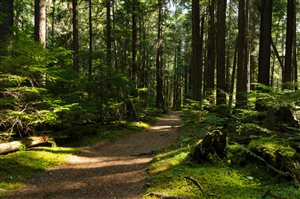
The Pacific Northwest trail is beautiful, scenic and unique. It offers the hiker spectacular views, while cutting through several miles of mountains, valleys, and wilderness. Hikers also get more experience on this trail, considering the challenging nature as it passes through the wilderness.
A Sense Of Direction – The Pacific Northwest Trail
Navigation
[jbio template=”bootbomb0″]
0 comments