
Facts and Statistics
 The Long Range Traverse in Newfoundland is a 35 km backcountry nature trail highly reputable among long distance hikers. This storied traverse follows the valleys and ridgelines of the highest peaks in Newfoundland ascending to 2,500 feet above the west coast of the island. Set in Gros Morne National Park, the landscape is both dramatic and remote. It is characterized by glaciers carved from uplifted, massive blocks of granite forming the plateau.
Several fjord like, land-locked water bodies can be found in the area. Locals call them ponds. Then Newfoundland is a sparsely populated area, with an estimated population of 12 people per square mile. It is a place full of surprises and understatement. It is the easternmost point in Canada, which is gaining worldwide popularity, as a backpackers dream.
 Newfoundland has been attracting visitors from both North America and Europe in increasing numbers in both summer and winter. One of the biggest attractions is the Long Range Traverse. It is a wilderness route cutting through hills and mountains in the Gros Morne National Park. You will require a water taxi to begin while excellent compass and map reading skills are needed for successful completion.
You should know that there is no clearly marked trail here, therefore, you need to sharpen your backcountry navigation skills, before you can be allowed to step into the wilderness. In some instances, park wardens might require you to go along with a locator beacon before you can be even given a hiking permit. The idea behind this concept is that you can be easily found when you get lost, if you have a transmitter, rather than searching through the vast mountains and forests.
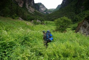
You realize you are in for a special hike as soon as the water taxi drops you at the end of the Western Brook Pond. This is where you begin your five-day long hike, through the Long Range Traverse. From the pond, there is a steep gorge passing through overgrown and complicated bushwalk with waterfalls spreading spray on your outwear.
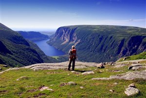
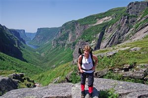
 Once you manage to clear the weeds, you can clearly see the majestic inland fjord, disconnected from the eons of the sea by a massive glacial moraine. The narrow long water body is defined by high rock walls, some even going for up to a thousand feet.
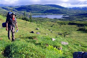
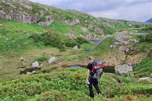
Once you are on top of the gorge, you can clearly see what lies ahead of you: rolling peaks, mountain meadows, and shimmering lakes, that stretch out as far as you can see. It is a stunning expanse of the wilderness with everything almost looking alike. Navigation up the gorge is easy, when you compare it to what you are about to encounter ahead. From there, you are going to pass through rugged terrain, with very few landmarks that you can rely on. Dense alpine vegetation is found throughout the trail, which makes it hard even for experience hikers. This vegetation is so thick that you cannot force a trail through it. This means that you will have to circle it, which makes navigation even more complicated.
The next few days of your hiking will be an engaging combination of compass bearings, GPS observations, dead reckoning, and map reading. You don’t have time for daydreaming on this trail. One of the biggest surprises when it comes to hiking on this trail is the sheer scale.
 You can navigate from peak to peak only to see that the lake that you thought was right there is 100 miles away. When hiking in the Long Range Traverse, the wildlife, especially caribou and moose that can be found in abundance adds to the wonderful nature of this terrain. This makes it one of the best wilderness areas to go for a hike, in eastern Canada.
The authentic challenge and that vast scale is what makes this terrain all the more interesting. There are very few hikers bold enough to go out in the wilderness like this. As such, you are likely to encounter very few people. There are no crowds, as characterized by other long distance hiking trails.
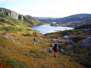
As you approach the final days of your hike, you will most likely find yourself beyond Green Island Pond. The geography will squeeze you between several ridges and the descent above Ten Mile Pond. This provides you with a perfect perspective of the fjord like ponds. You will always remember this vantage point. It is an amazing route all the way, which explains why the Gros Morne National Park has remained a UNESCO world heritage site for more than twenty years.
Season
 There is likelihood of bad weather, as such, you should consider it an alpine route despite the fact that its highest point is below 3,000 feet. With that in mind, the best time to visit is during the summer. The advantage is that the summer season here is longer when compared to other alpine routes. May to September is considered a suitable time for this trip. However, most hikers go there around July and August. Off-season comes with its advantages such as fewer bugs. However, you are most likely going to encounter bad weather, which is going to spoil your trip.
Risks
 Since is located on the edge of Gulf St. Lawrence, it crosses the path of major weather systems. The whiteout, the storm and the fog pose some of the greatest risks when hiking this trail. due to the absence of markers, and the heavy reliance on your own navigation skills, it is not advisable to travel when the weather is not clear.
Have enough food supplies and sufficient camping gear, such as sleeping bags and outdoor backpacks, to be prepared for such risks. Large mammals such as caribou and moose can also present a potential risk. However, you just need to be aware of your surroundings and avoiding them when they appear violent. Navigation is your other concern. Failure to stay on course means you will not appear at the end of the route.
Conclusion
The Long Range Traverse is best hiked from Corner Brook city. It is served by an airport in Deer Lake town. This is the gateway to Gros Morne National Park. Although Corner Brook is quite far from Gros Morne National Park than the town of Deer Lake, it has a wide array of services, which makes it easy to access the traverse. You should do this route at your own pace. Just be careful with navigation within the wilderness, and you are bound to enjoy a hike of a lifetime.
Youtube User ‘The Again’ Hikes The Long Range Traverse
Navigation
[jbio template=”bootbomb0″]
0 comments