
Facts and Statistics
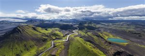
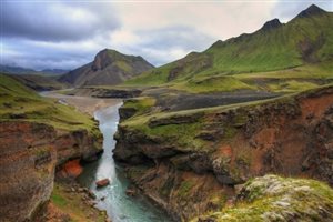 Ranked as one the 20 best hikes in the whole world by the National Geographic, the Laugavegurinn/Fimmvörouháls trail starts at Landmannalaugar, a wonderland of geothermal activity. It then takes you south through highlands, red and yellow mountains, fields of obsidian, sparkling white glaciers and black sand. The Laugavegurinn trail then concludes at Thorsmörk at the foot of the beautiful glacier Eyjafjallajökull. From there you will hike to the craters of Fimmvörouháls Pass.
About the Trail
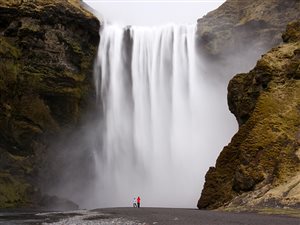
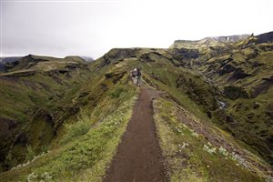
This trail provides a short but strenuous hike of around 78 km. it cuts through colorful mountains, perky summer flowers, spellbinding vistas, photogenic alpine lake, steam vents for warmth, snowy trails and boiling mud pots. On top of that, you will also encounter river crossings, black and green misty mountains, black lava rocks, enchanting forests, a waterfall and the alpenglow at sunset. At the end of the trail, the grand Skogafoss falls await you.
 Several huts along the trail provide an alternative to carrying cooking gear and tents. They are warm and cozy, despite the shared bunk beds and kitchenette. It is advisable to book your reservations early, since they fill up well in advance when the hiking season is approaching.
This trail should not be taken for granted. Although it is well marked, spotting can be made difficult, when there is falling snow. When you hear that conditions change rapidly, then that is the truth with this trail. Hikers passing through the Morinsheidi heath have encountered dropping temperature from hot and bright sunshine to high winds and sleet, with freezing.
A challenging section, the Cat’s Back is not for the faint hearted. Located on the Fimmvorduhals Pass, it is a narrow, arched section featuring sheer drop offs on both sides. As you advance, other sections need hand-over-hand climbing. The last challenge along the trail is a small exposed section that includes chains to hold on to, to remain assured.
Getting There
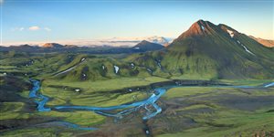
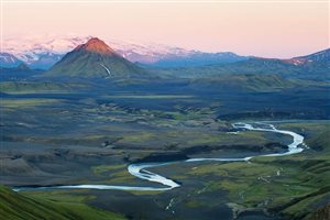
 It is situated in the southern highlands and most hikers prefer hiking from north to south. In that case, you will start at Landmannalaugar that is lying 600 meters above sea level and end at Þórsmörk at 300 meters above sea level. During the high season, several scheduled buses drop and pick hikers from the starting and end points of the trail.
Since it is situated in the southern highlands, this trail can only be serviced few times per year. Camping huts start opening around 25th June closing at the start of September. Snowmelt and other weather conditions can alter those dates. Considering nature and security reasons, you are advised not to hike the Laugavegurinn when the huts are not open.
There are six huts along the trail, where you can plan for your accommodation. The huts, the guests, and the tracks are taken care of by wardens, who are also eager to provide information about the trail and first aid services. Inside the huts, guests can expect bunk accommodation, shared kitchen equipment, running cold water, gas heaters, water toilets, and showers. Beddings are not provided. A certain fee is charged to spend the night inside the huts, payable through cash or credit cards.
If you are not eager to use the huts, then you can opt for camping. Camping facilities are attached close to the huts. If you intend to do camping, then you don’t have to book in advance. You can access showers, running cold water, toilet facilities, and garbage disposal. Camping outside the designated camping zones is not allowed by law. This was necessitated by the increasing number of hikers, thus the need to take care of natural reserves and security reasons.
Nature Protection
 The Icelandic highlands are comprised of sparse vegetation that is very prone to erosion and stress. Those thick moss layers that appear sturdy and soft can be destroyed by one step. Therefore, hikers are requested to use only the designated tracks and to avoid sitting on mosses and plants.
With the same reason in mind, hikers are requested to carry their waste and dispose it at the next hut, even if it’s a tissue paper. Taking care of nature helps to preserve the trail, so that the upcoming generations can enjoy the same adventure you have.
Hiking the Trail
 Good equipment and physical fitness go a long way in determining your success along this trail, despite the weather. It is therefore advisable to engage in a physical fitness program two months prior to your departure. This practice will include carrying your full packed bag, or a similar weight up and down the stairs, to keep you in good condition.
This trail will involve carrying up to 20 kg of pack weight, up to 16 km every day. You are also expected to ascend to 1000m, spread over 10km during the first hiking day as you approach Hrafntinnusker. Rocky, slippery, rough surfaces and steep declines are some of the terrain that you are likely to encounter. Including at least one rainy day and crossing icy glacial rivers with up to meter-deep water.
When the weather is good, you will encounter beautiful views of the scenery. With horizontal rain and freezing temperatures, then you will not view anything at all. It is considered an alpine hiking trail. As such, steep, slippery, and rocky ground surfaces cause accidents each year. However, you should not be worried, since there are more than 100 hikers during the season, who are always willing to help.
 The highest crossing you are likely to encounter is on the first day, at an elevation of 1100 meters above sea level. With the arctic environments in Iceland, this would compare to 3,000 meters above sea level in the European Alps. As such, weather conditions are not predictable, and can change rapidly. Check for weather warnings and current conditions, before commencing your trip. Bring along good boots and warm water proof clothing.
Bottom line
During good weather, the Laugavegurinn or Fimmvörouháls Pass in Iceland is a suitable hiking trail for most hikers. It is also one of the most beautiful in the country. During bad weather, conditions can be very risky, for both amateurs and experienced hikers. Expect snow during July and august, while fog is a common feature. Correct estimation of your capabilities and correct clothing is necessary. It is a trail of extremes on both sides. In good weather, it is extremely beautiful and extremely dangerous during bad weather.
0 comments