
Facts and Statistics
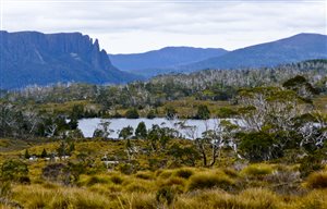
 The famous 65-kilometre Overland Track takes you through the Tasmania’s wilderness that is listed as a world heritage site. It starts Cradle Mountain, and ends at Lake St. Clair. You can cover the entire trail in six days or opt for short day trips in several sections of the trail.
If you intend to undertake the thru-hike, then you need to do careful advance planning. You have to make prior arrangements with Tasmania’s Parks & Wildlife Service on top of a warm sleeping bag and a good tent. For a comfortable hike, this trail can be divided to six sections.
Ronny Creek to Waterfall Valley
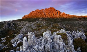
 The first section involves ascending to the craggy of Cradle Mountain. It is a 10 km hike that starts at Ronny Creek, past the moderate climbs at Crater Falls and to Marions Lookout. You can also use the track that goes past Horse Track but it is less challenging. Another option is starting off at Dove Lake and ascend past Lake Lilla, all the way to the Marions Lookout. This section offers you amazing scenery, coupled to the silent waters of Dove Lake.
Go past the Cradle Mountain plateau until you reach the summit nestled at an altitude of 1,500. From the summit, you can circle the glacier section taking a right turn, which will take you to Barn Bluff. Descend through the highlands, as you watch out herb meadows, button grass, possums, and wallabies in the trees. Spend your night in one of the established campsites.
Waterfall Valley to Windermere Lake
 This section offers a walk through sections with happy mountain birds, like the yellow-throated wattle. You will get to enjoy lots of clean mountain air. An 8 km section is going to take around three hours, on moderate hiking speed. Make sure to bring supportive walking shoes for this section. This gives you enough time to enjoy the surrounding scenery. Starting at the Waterfall Valley, the trail takes a southern direction, going past sedgeland moors, filled with eucalyptus trees, pandani bushes, and exotic pencil pines some said to be up to 1,000 years old.
Take your lunch break at Lake Will amid beautiful scenery then head to the southern end of the lake where you will find Innes Falls. Take a turn at Holmes lake and head straight to Lake Windermere, passing grass plains. You can take a refreshing swim at this lake, and then head to Forth Valley, providing you a view of the green, fragrant Lemonthyme Forests. Spend your night in one of the huts at Windermere as you listen to the nocturnal possums.
Windermere Lake to Pelion Plains
 Prepare for a 17 km hike as you cut across mountains and moorlands. From Forth River, view the glacial valley and the great eucalyptus forest around it. Starting at Pine Forest Moor, you will go past moss covered forests, under the rocky protrusion of Mt. Pelion West. Take your lunch at Frog Flat, as you enjoy a sweeping breeze under the dolerite peaks of the mountain. You will encounter the waters of Forth River Cascade as they make their way to the Lemonthyme valley. You will follow their direction, descending through sassafaras, leatherwood, alpine grasslands and myrtle rainforests, and finally to the Pelion Plains. This section of the track coincides with a horse trail built in 1898, mainly used for transporting miners to the mines in the West Coast from the eastern towns. Enjoy your night in one of the Pelion Huts that were recently built.
Pelion Plains to Kia Ora
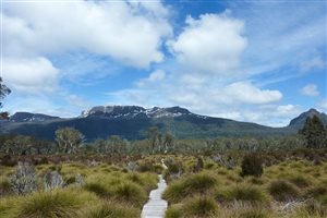
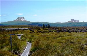
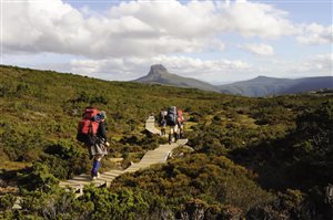
 The South-West wilderness stretches right before your eyes, providing endless views of bushes and other features. This 9 km stretch starts at Pelion Gap. You will pass through emerald forests through slopes lined with eucalyptus forests, and then come to a clearing. Mount Cathedral is visible from here. Mount Ossa and Pelion East are on either side of you.
If you are an experienced climber, then you should have time to climb Mount Ossa, which is a three hour round trip. This is the highest peak in Tasmania. The summit provides a prime viewing point, as you view side of Cradle Mountains. Ascend to Pinestone Valley, across cushion plants, scoparia and ancient pines. Nestled under the Cathedral Mountain is Kia Ora Hut, where you can spend the night.
Windy Ridge
From Kia Ora Hut, the next stop is at Windy Ridge. A 10km stretch will mainly take around four hours. Visit Du Cane hut and Leatherwood Gardens. Du Cane hut was once used by Paddy Harnett as a bush home. Explore the scenic Leatherwood Gardens full of large white flowers during summer and spring. Go south and explore the Mersey River area, as you adore the largest and most spectacular falls in the area – Hartnett, Fergusson and D’Alton. Passing through Du Cane Gap, you will head straight to the dense myrtle forests and then arrive at Windy Ridge. There were numerous large boulders at the entrance of this ridge, which slightly shifted when the last ice age occurred. After that hike, spend your night at one of the nights at Windy Ridge, or camp at a tent.
Lake St. Clair
 Your final journey will include an 18 km trip including any side trips that you might want to add. This journey takes you through eucalyptus forests, including the grassy section of the Bowling Green. The summit of Mt. Acropolis is visible from here. Continue south as you pass through Pine Valley, under the Du Cane Range, that is always shrouded in mist.You will find a bridge crossing taking you to Cephissus Creek. You can then ascend Mount Acropolis as you view its elegant lakes. Your hike concludes with a boat cruise on Lake St. Clair. This is the deepest lake in the southern hemisphere.
Bottom Line
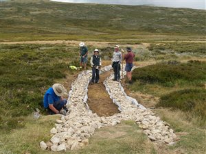
Along the trail, there are around eight stove-heated huts. However, space is not guaranteed. The best time to go for the hike is November and April. During this period, the weather is somehow mild, while the days tend to be longer, which translates to Daylight savings. In April, the deciduous beach provides allows you to view stunning changing colors. Apart from the physical challenge, this trek puts you with an unforgettable interaction with nature. You will see gorges, forests, lakes, moors, mountains, steep stony peaks, and spectacular waterfalls.
Youtube User ‘Danny G’ Hikes The Overland Track
Navigation
[jbio template=”bootbomb0″]
0 comments