
Facts and Statistics
 The Te Araroa Trail is among the newest long distance trails in the world today. It connects island to island, north to south, people to people, and beaches to mountains. Opened in December2010, the trail is 3,000 km long. It takes hikers over volcanic mountain ranges, through blossoming rain forests, along beaches and through beautiful landscapes.
The trail begins at Cape Reinga, from there hikers go southwards for approximately four months, finishing off at Bluff, at the southern tip of New Zealand. It is attributed to a New Zealand journalist, Chapple. He came with the idea of creating a long distance trail as a means of uniting a politically divided country together. It was initially a theory, but the idea gained popularity widespread recognition. Chapple hiked across New Zealand marking out the entire trail. the trail is managed by Te Araroa Trust that continues building and improving sections of the trail.
Walking the Trail
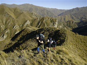
 The trail has more than 300 sections. They range from 2-hour walks to 9-day routes in the South Island where you must wear proper footwear and carry full equipment. more than 40% of the trail cuts through conservation land. Using a straight line, the distance from Cape Reinga to Bluff is around 1,475 km. however, that is not practically possible since the trail has to go round mountains, descending valleys and cross streams, brining the nominal distance to 3000 km.
Numerous portions of the trail are quite challenging. Such sections of the trail require good planning, river crossing and navigation skills. On top of that, a good level of fitness is recommended. For thru-hikers, the trip will take between 3 to 6 months to complete.
Apart from the section at Queen Charlotte track on the South Island, the other sections of the trail do not require permits. The trust that manages the trail requests a donation of NZ$500pp for thru-hikers and NZ$250 for day trips. These funds are used to maintain the trail in good condition throughout the year.
Northland
 Most thru-hikers tend to start their journey at Cape Reinga towards the north section of North Island. This region is mainly remote characterized by lonely sand stretches facing the Tasman Sea. There are also dense forests, fast rising rivers and steep hills. The touristy and relaxed towns of the Pacific Ocean provide a comfort and perfect contrast to the worn out hiker.
The trail provides everything from backcountry hikes to cruisey beach walks. Challenges on this section include crossing numerous water bodies where you have to wait for the levels to subside or do pack floating.
Waikato/King Country
 You are going to encounter history, with every mile of the Waikato River bend. The name of the region is derived from this historic river, which also gave the original Maori inhabitants a source of livelihood and nourishment. The Maori are spiritually connected to this river with every bend symbolizing a chief.
From the north, the Te Araroa enters Waikato along this river. You will also pass through a short excursion at Hakarimata Range. Follow the trail up to Hamilton, where it then ascends Mt Pirongia. This mountain is a feature you will not miss out in this region, since it dominates the entire skyline.
The trail then enters King Country, characterized by rich pastoral lands. It then passes through Te Kuiti. This is the where Colin Meads came from. He is regarded as one of the greatest All Blacks. The trail then cuts through central North Island forests, then exits at the foot of Tongariro Mountains.
Wanganui
The landscape changes from the mountain to the sea. You are going to pass through bush and a large river, and likely to face all elements of nature. Along this route, you will encounter two national parks, the Wanganui and the Tongariro. Both are spiritual and dramatic places. The city of Wanganui has a rich European and Maori history, spread throughout the district.
The route will take you through some very remote areas that have minimal resupply points. Therefore, you need to organize your trip accordingly. You need to think and plan ahead as well as organize your accommodation and food requirements in advance.
Manawatu and Wellington
 From Wanganui, the trail enters Manawatu from the town of Bulls. It then passes through pastoral landscapes through the town of Fielding, and finally arrives in Palmerston North city. From there, you will get an opportunity to resupply at Levin, as you savor the Tararua Ranges.
The trail then takes you to Wellington, through the Tararua Ranges. This is one of the most challenging sections of this trail. It then approaches the Kapiti Coast, before passing through exposed ridgelines, providing some spectacular views.
Marlborough
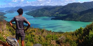
Marlborough is in the South Island section. It starts at Ship Cove, winding through the pretty bays and forested ridges of Queen Charlotte Track. Hiking is easy, with water taxis that can carry your luggage if you feel the need. However, it provides an ideal way to get used to the southern trail section.
The trail gets challenging is it goes south towards the Richmond range. The trail ascends mountainous terrain and scree with an elevation of up to 1,870 feet. through the Nelson Marlborough, the terrain ranges from easy to testing. Therefore, it you can get through this section, then you can comfortably handle each other section along the way.
Canterbury
 The trail takes you to a crossing of Main Divide, through Harper Pass Track. You will pass through beech forest, grassy cattle flats, and across spring-fed hot pools. It is more wet and rugged here with major rivers and forests to negotiate, which might slow down your progress. After crossing the Main Divide, the trail takes you east over Goat pass, a section normally used for mountain racing.
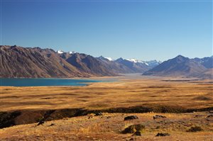
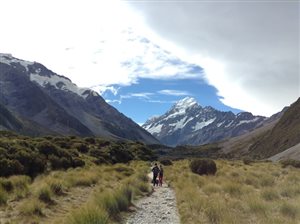
Te Araroa then passes through Craigieburn Forest Park to the east of Arthurs Pass. it then takes you through Mackenzie Basin, with scintillating mountain views and turquoise lakes. When the weather is fine, you might view the peaks of Mt Cook. It then passes close to Lake Pukaki Shores, before entering Twizel.
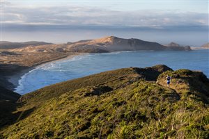
From there, the Southland section beckons, with a smell of finish line in the air. From the windswept coast, the eerie mountains, the stunning Mavora lakes, the trail ends with the same beauty and diversity encountered along the trail.
Bottom Line
There is no specific time of visiting the Te Arora Trail. However, if you are Southbound, it is advisable to start between September to December. If you are northbound, then you should start between November and January. These are only broad guidelines.
YouTube User ‘Andrew Bares’ Hikes Te Araroa
Navigation
[jbio template=”bootbomb0″]
0 comments