
Facts and Statistics
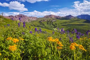
 The West Maroon Trail presents hikers with wonderful views of the Pyramid Peak and Maroon Bells. two stunning lakes, a scenic alpine basin and pretty waterfalls are some of the other amazing features found on this trail. It is a 13-mile hike that follows the Maroon-Snowmass trail all the way to the Crater Lake. It climbs through the narrow and long West Maroon valley, under the pyramid massifs and the Maroon Bells.
Trailhead to Crater Lake
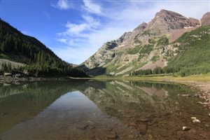
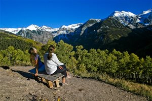
Hiking from the trailhead to Crater Lake is a distance of 3.4 miles, if you consider going for the round trip. The highest elevation on this trail is around 10,000 feet, with an elevation gain of 496 feet. There are very few trails that can match the stunning views along this trail. In the waters of the lake, you will see a spectacular mirroring of the Maroon Bells. On the other side are the Pyramid Peaks crags that rise to the south. To the north are the beautiful aspen groves formed by the crimson spires of Sievers Mountains. It is a spectacular view to behold.
 Following the maroon snowpass trail, you will come across a junction that is near the head of Lake Maroon. Do not expect to cover a lot of ground on this section. Your progress will be slowed down by the numerous spectacular views that you will stop to admire. It is just hard to pass without taking photos of this amazing scenery.
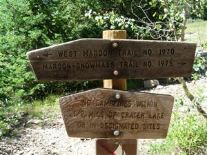
Once you hit the junction, maintain the Maroon-Snowmass trail. It is going to turn right, climbing to a rocky, wide path. The trail then ascends to the northwest side of the valley, cutting through spruce and aspen forest. The forest is not very dense, which means that there are numerous openings within the trees. These openings in the trees will allow you to view the rugged Pyramid Peaks that rise to the south. There is a natural dam that was created by an ancient rockslide that is about one mile from the start of the trail. This dam forms Crater Lake. Once you hit the top of this rockslide, you will enjoy wonderful views of Maroon Bells.
The trail then descends gently from the top of the slide to Crater Lake. Just before you reach Crater Lake, you will arrive at a junction that is approximately 1.7 miles from the beginning of the trailhead. Go straight towards West Maroon Pass and Crater Lake. If you follow the trailhead going west, you will arrive at Buckskin Pass.
Crater Lake – West Maroon Pass
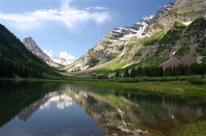 The distance from the trailhead is around thirteen miles, doing the round trip. The highest elevation on this course is approximately 12,500 feet while the elevation gain is around 2950 feet. From Crater Lake, you are going to descend slightly and then follow the trail as it cuts across the western shoreline of the lake. The Maroon Bells will present you with wonderful views as you hike along the trail. At the end of the lake vista, a valley opens up. The western side of the valley is filled with cascading waterfalls, which make this trail even more appealing.
From the valley, the trail is the going to follow a gentle grade, as it passes through the meadows, trees, and willow thickets. The trail then takes you to a steep rockslide climb, and then spills over to the eastern side of the Maroon Peak. Once you reach the top of the slide, turn around, and enjoy some spectacular views of the valley beneath.
 After the rockslide, the trail passes through a narrow corridor between the talus fields and the creek, passing through conifer stands and willow thickets. As the corridor gets narrower, the trail passes through several talus fields. You will then be forced to cross to the eastern side of the creek, as it constricts further. When hiking early in the season, you will have to wade through the creek, although the water levels are not high. Later on, the snow forming streams subsides, which allows you to rock hop to cross the channel without your feet getting wet.
Once you cross over the east side of the trail, the trail gets steeper as it passes through thick sections of willows. It then continues ascending through conifer stands interspersed with a areas of scrub growth. There are some nice camping spots in this section of the hike. Going with the time of the year that you do your hike, you might encounter some waterfalls on the eastern side of the valley, along this section of the trail.
 After hiking for around 4.5 miles, then trail will then cross back to the western section of the creek, continuing its climb. The trees start to disappear, as you encounter scrub willows thickets. Towards the head of the valley, the climb steepens further. As you climb, turn around and enjoy the wonderful views presented by Pyramid massif. When you reach the valley head, you are going to come across a large basin filled with maroon cliffs.
From the basin, the trail takes a western direction, as it passes through the rolling landscape. As you get near to the ridge, the pass becomes clearer. The final journey through the stiff ascent and meadows is around 800 feet.
The Treasure Mountain is on the west side of the pass. Below it are the extensive meadows of the Purity Basin. The Pyramid massifs and the Maroon Bells fill the skyline on the northeast side of the pass. The northwest side is filled with the rugged peaks of Belleview Mountains. Most day hikers turn around when they reach this point. On the other hand, most backpackers will use the trail as the last or first leg of the Four Pass Loop.
Conclusion
 If you do proper planning, you can cover the entire trail within a single day. However, others will prefer to make it a two-day trip. This will enable then to enjoy all the beauty along the way. You can then consult your map and find the East Fork trailhead, which is a short distance from pass. There is always a car at Schofield Park trailhead where you can arrange a taxi. You can also walk back to the Crested Butte. However, this route is not recommended, since it is not travelled frequently. And if you are going to travel it, make sure to bring really good walking shoes (men’s shoes, women’s shoes).
YouTube User ‘John Milne’ Hikes From Aspen To Crested Butte
Navigation
[jbio template=”bootbomb0″]
0 comments