
Facts and Statistics
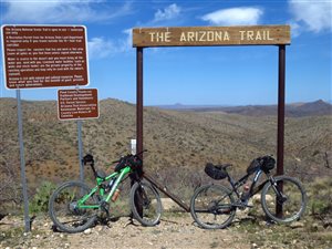 Officially known as Arizona National Scenic Trail, this is a hiking travel running from Mexico to Utah. The Arizona national scenic trail starts at the US-Mexico border and terminates at the Arizona-Utah border. It passes through the entire length of the state of Arizona, going from north to south. It stretches for more than 800 miles, connecting, mountains, deserts, canyons, forests, unique scenery, and wildlife.
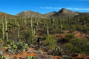
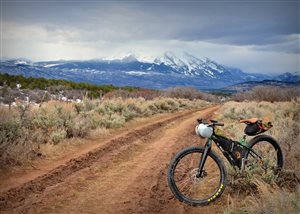
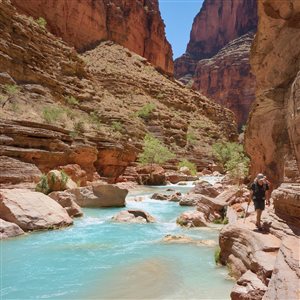
It is a non-motorized hiking trail showing the diverse scenery, wildlife, and vegetation in Arizona, including the unique cultural and historic sites. This route provides equal opportunities for mountain bikers, equestrians, hikers and other trail users. It is divided into 43 passages, some of which are discussed in details below.
Huachuca Mountains
 This section stretches from the Mexico border all the way to Parker Canyon Lake Trailhead. It is 21.7 miles in total and can be accessed from Sonoita Town. Starting at the Montezuma Pass, follow the hiker-only access that will take you to the southern part of this trail. Follow the Coronado Peak Trail, all the way to the Yaqui Ridge Trail.
Going back to the Montezuma Pass, the trail follows the Crest Trail, which leads to the Miller Peak Wilderness. After this strenuous and steep ascent, the route ascends further, passing Lutz Canyon Trail. It finally takes you to Miller Peak Spur Trail. After the spur, the route follows a ridgeline, going over to Tub Spring. It then takes a left and uphill direction towards the Carr Peak and Crest Trail Junction.
After the Oversite Canyon Trail, the trail goes left, coinciding with the Sunny Side Canyon Trail. It follows this route all the way to the wilderness boundary. At this point, it follows a dirt road for some few miles, then turning right, and comes across the Scotia Canyon Trail. After this section, it crosses FR48, turning west and reaching Parker Canyon Lake Trailhead.
 This passage is moderate to difficult, when hiking. The best time to visit is between summer and spring. Water can be found at Bathtub Spring/Tub Spring and Parker Canyon Lake, although this is a seasonal store. It is advisable to carry sufficient water, since this section can be dry and hot. Before setting on for the hike, inquire about the current conditions of the route, maintenance status, and the weather.
Mazatzal Divide
This section is approximately 22 miles, stretching from Mt Peeley to the Park. This entire section is located on Mazatzal Divide Trail. From Cornucopia trail, the route winds around Mt. Peeley, passing through the wilderness boundary. After the drainage head, it turns straight north, following a ridgeline. It circles and unnamed park anticlockwise, then descending to the Bear Spring cross section.
 It ascends over the same ridgeline and heads to the Shake Tree Trail junction downwards. The trail continues with a northern direction, then descends, passing the Mazatzal Peak along the way. This section is characterized by climbing and dropping down, which can be very challenging for any hiker.
Going downhill, the trail passes Chilson Spring, and then ascends Deadman Creek. It reaches Hopi Spring, crossing the upper section of Deadman Creek. Heading northwest, it begins descending towards the eastern side of Maverick Basin. The trail follows a north, and then heads west before finally arriving at the park.
Hiking on this section is moderate and can be done throughout the year. However, it is good to know that snow can form during higher elevations while excess heat can be felt at lower elevations, especially during summer. You can find water at Chilson Spring, Horse Camp Seep, Hopi Spring, and Bear Spring. This section is not suitable for mountain bikers, since they are prohibited.
Coconino Rim
 The southern trailhead is at Moqui Stage Station while the northern trailhead is at the Grandview Lookout Tower. This whole passage is around 19 miles. Beginning on the eastern part of Moqui Stage Station, the stage connects with the route through a small connector trail. The trail then takes a northern direction then crosses FR 320. It then goes northwest, north, west, and north again. You will find a gate, Russell Tank Trailhead, then two more gates.
The trail then crosses Coconino Rim road, then comes across another gate. It will bring you to the edge of the rim, and later turns west, in close proximity to the rim. The main route goes west, while a bike bypass takes the right. Following the drainage, the trail crosses a peninsula, and then leaves the rim. After crossing FR 307, the trail will then lead you to the Grandview Lookout Tower.
It should be an easy part of the trail to hike and can be done all year round. There is snow during winter. For water, you can resupply at Russell Tank. Purify all water along this route before using, to avoid contamination. As long as you keep close to the trail, you will not need any permit.
Grand Canyon – North Rim
 The southern trailhead is on the North Kaibab Trailhead while the northern trailhead is at Kaibab National Forest boundary. The entire section measures 12.6 miles. This section starts at North Kaibab Trailhead, which is on the rim of the Grand Canyon. After crossing highway 67, the trail heads northwest.
It cuts across Harvey Meadow, takes a steep ascent, and crosses a road. It then evens out, and takes a northwest direction. It passes through meadows and forests, heading to the north, then crosses highway 67. After the highway, the trail turns left, and runs parallel to the highway. It attains a high point, before dropping close to the highway again. It enters Grand Canyon National Park, follows a service road to the right, and then turns left to the park boundary.
It is an easy to moderate passage to hike and can be done during fall, summer or spring. Water sources are unreliable and scarce, therefore, it is advisable to carry your own water. The facilities on the North Rim are closed between mid October to mid May. The trail ends at the Kaibab Plateau, which is near the Arizona-Utah Border.
Bottom Line
This 1,300 km long trail was finally completed on 16 December 2011. It is designed for mountain biking, equestrians, hiking, and cross-country skiing. It showcases a wide variety of ecosystems and mountain ranges of Arizona. The terrain can get quite rough and if you’re going for a long hike, you’d better bring a couple of solid boots (men’s boots, women’s boots).
The Walk Across Arizona
Navigation
[jbio template=”bootbomb0″]
0 comments